What WILL you make with a GPS enabled or very detailed track editor?

  • Thread starter smskeeter23
  • 1,100 comments
  • 110,740 views
Lydden Hill, because rallycross

lydden_hill_circuit.jpg
 
Actually, you'll get a better track by going slowly - more data points.

I was talking about more specificaly about going against the road rules (direction) to get the perfect circuit (in a car, of course, because going on foot or using a bike this is not a big deal). But i was only making a joke, so no worries.
 
I hope I can create this track in Ronda (so it will be complete with scenery).
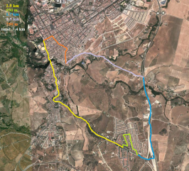
7.4 km long, through some beautiful scenery. It contains some high speed sections, combined with narrow, technical roads.

Yellow: High speed, but quite twisty.
Green: Narrow, but quite fast, street section
Blue: High speed
Purple: Twisty, very narrow
Orange: Narrow city streets
 

Attachments

  • track1.png
    track1.png
    480.6 KB · Views: 10
I would like to make two courses...

1. "Legion Seca"

there is a hill by my house that is similar looking to the corkscrew at Laguna Seca...except at the bottom of the hill it ends up being about a 180 degree turn...it also happens to be right near an American Legion hall...so going back to middle school my friends and i named this little ~1.2 mile loop of road "Legion Seca"

the bottom right hand corner of the map is where the "corkscrew" is...its probably a 50ft drop in elevation down the hill to a 180* turn...it would be intense lol

legion-seca.png


2. "The Goat Trail"

a ~4 mile stretch of road that runs from one side of the Hudson River and ends with a sprint across the Bear Mountain Bridge...Point B is sea level...you then climb roughly 400-500 ft before coming back down towards the bridge

goat-trail.png


nothing really does it justice...but here is an OK video

 
If it all works out, I'd like to do this little street circuit around Edmonton, Alberta.

Start at D, going clockwise. Drops down into the river valley, then a big gradient up to point B. Down the main drag of Jasper Ave, right past the historic hotel, and then another steep decline down to the river valley, across the bridge, and then a fast climb back up to start/finish.

Screenshot_2png_zps16acf0e4.jpg
 
I was thinking of walking the route around Manchester city centre, I mean it doesnt matter how the course is logged right? I'll just pre plan then walk the whole city centre route

I like the look of the Dublin one
heres a clip of it.
 
Mondello Park, My way to work and back, Go kart track in the city.
And with the Course Maker, I will try to replicate Ebisu, and some other tracks probably.
But first i will have to learn how to use it.
 
Untitled-254_zps8ce3836a.jpg
[/URL][/IMG] Another one I mapped out. It runs right in front of my house and can be configured up to 3 different ways. First is known as the Beltsville Loop (my hometown.) It is connected to a smaller loop known as the Odell loop. Both can be combined to form a huge, Nurburgring-type track.

Second is the Woodlawn Manor track I mapped out earlier in the thread.
Untitled-186_zpsa79ad1bd.jpg
[/URL][/IMG]
 
I really hope we get to choose the type of scenery we want for our tracks. It would be kind of pointless if that option isn't available.
 
3. To the grocery store and back

Yeah, I've always wanted to know how fast I could get there in a fast car with no lights. Now I can find that out.

Other than that, I look forward to content from other drivers. Someone mentioned the Dragon's Tail. That would be awesome. There are also some really great drives in NW Arkansas. Likewise in Colorado. I can't wait to see what all the rest of you are able to record. This is going to be amazing.

Some of the roads in NW Arkansas would be great to have tracks. I remember that area when I was visiting relatives in Rogers, Arkansas and they took me to the War Eagle Mill and there were some nice curvy, elevated roads up that way South of Eureka Springs. Some tracks that incorporated parts of I-540 with the tunnel would be great, too.

I would like to see some routes made of the Blue Ridge Parkway in North Carolina. Those would make some great tracks with the changes in elevation with curves. One of the earlier and I mean earlier racing games released for the Playstation 1 had a generic race route of the Blue Ridge Parkway. I think the game Test Drive may have had the Blue Ridge Parkway in it. Does anyone remember what game this was?
 
I look forward to being able to possibly make tracks with Mobile Apps' GPS Data in Gran Turismo 6 no matter how basic the tracks are to be made in Course Maker. Any kind of addition to making courses like this greatly enhances the playability of GT6 and would be a feature that would sell many more games than would otherwise be possible. I for one was excited to see the possibility of this technology. I look forward to seeing an announcement of this great feature.
 
I love that road, but I think that the game will only track the Earth's contours so instead you'll probably get a fairly flat route that pretends that the Clyde doesn't exist!

Hahahaha. yeah it's all in the elevation changes.

But those running GPS apps defo log elevation?
 
Glasgow Scotland including the Clyde tunnel and Kingston Bridge!!! This is the Glasgow Clockwise Orange!!!!
Glasgow Clockwise Orange.png

The orange part are 3 lanes motorway and the rest is dual lane.
 
I've just realized... How is this GPS track creator going to deal with roundabouts?
 
Last edited:
I've just realized... How is this GPS track creator going to deal with roundabouts?
It doesn't know anything about the terrain you are driving on, it is only creating a path, possibly with elevations. It'll draw whatever portion of the roundabout you drive on as a semi-circle.
 
It doesn't know anything about the terrain you are driving on, it is only creating a path, possibly with elevations. It'll draw whatever portion of the roundabout you drive on as a semi-circle.

:lol: Well that's going to be awkward. Small roundabouts will just look like errors in the construction of the track because they're just so small (like a small chicane that is so small that you could go two wide through it in a direct straight line). Maybe I'll just drive over the top of the small roundabouts. :lol: And when I get pulled up by the police, I'll explain that I'm getting data to make a Gran Turismo track.

I have a few local roundabouts which are absolutely tiny.
 
Back